Free Photos (Public Domain Photos),stock Photos, Clipart, images, and Vectors

A large Public Domain photo repository with high resolution free photos and vectors. All copyright free stock photos and royalty free photos, and CC0 Photos. 27000 free and public domain photos, images, clipart, pics and vectors and counting. To view/download a photo in high resolution, please click on the image.

Sponsored Images via Shutterstock: Coupon Code: GFP15 for 15% off
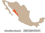
Sinaloa Location on Mexico Map Vector
Sinaloa state map. Federative unit of Mexico. Vector map for any needs
Sinaloa of Mexico map shape, travel web concept icon vector illustration .
Detailed vector map showing the administrative divisions (municipios) of Sinaloa, a state in northwestern Mexico. Ideal for geographical reference and regional analysis.
Coast of mazatlan sinaloa mexico
Detailed vector blue map of Mexico divide on regions - Sinaloa State. Template map for background, pattern, report, infographic. Administrative part of American country Mexico divided on regions

Public Domain Photos of Sinaloa